Pennsylvania Panoramic Maps Volume 1. The panoramic map was a popular cartographic form used to depict U.S. and Canadian cities and towns during the late nineteenth and early twentieth centuries (1847 to 1929.) Known also as bird's-eye views, perspective maps, and aero views, panoramic maps are nonphotographic representations of cities portrayed as if viewed from above at an oblique angle. Although not generally drawn to scale, they show street patterns, individual buildings, and major landscape features in perspective.
The panoramic map was a popular cartographic form used to depict U.S. and Canadian cities and towns during the late nineteenth and early twentieth centuries (1847 to 1929.) Known also as bird's-eye views, perspective maps, and aero views, panoramic maps are nonphotographic representations of cities portrayed as if viewed from above at an oblique angle. Although not generally drawn to scale, they show street patterns, individual buildings, and major landscape features in perspective.
Panoramic maps graphically depict the vibrant life of a city. Harbors are shown choked with ships, often to the extent of constituting hazards to navigation. Trains speed along railroad tracks, at times on the same roadbed with locomotives and cars headed in the opposite direction. People and horsedrawn carriages fill the streets, and smoke belches from the stacks of industrial plants. Urban and industrial development in post-Civil War America is vividly portrayed in the maps.
Victorian America's panoramic maps are quite remarkable in the perspective of the cities they capture. Most panoramic maps were published independently, not as plates in an atlas or in a descriptive geographical book. Preparation and sale of nineteenth-century panoramas were motivated by civic pride and the desire of the city fathers to encourage commercial growth. Many views were prepared for and endorsed by chambers of commerce and other civic organizations and were used as advertisements of a city's commercial and residential potential. These maps reveal much about the great contrasts and contradictions of the industrial age and the progressive era.
Preparation of panoramic maps involved a vast amount of painstakingly detailed labor. For each project a frame or projection was developed, showing in perspective the pattern of streets. The artist then walked in the street, sketching buildings, trees, and other features to present a complete and accurate landscape as though seen from an elevation of 2,000 to 3,000 feet.
Panoramic maps graphically depict the vibrant life of a city. Harbors are shown choked with ships, often to the extent of constituting hazards to navigation. Trains speed along railroad tracks, at times on the same roadbed with locomotives and cars headed in the opposite direction. People and horsedrawn carriages fill the streets, and smoke belches from the stacks of industrial plants. Urban and industrial development in post-Civil War America is vividly portrayed in the maps.
Here is a complete list of the city maps included in this collection. Where you see a city listed several times, there are several different maps - either maps created in different years and/or by different map making companies.
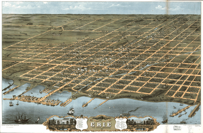
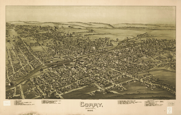
| 1. Alburtis / Lockridge 1893 2. Allentown 1879 3. Allentown 1901 1900 4. Allentown 1922 5. Allentown 1922 6. Altoona 1895 7. Apollo 1896 8. Archbald 1892 9. Bangor 1918 10. Beaver 1900 11. Belle Vernon 1902 12. Berlin 1905 13. Bernville 1898 14. Bethlehem 1877 15. Birdsboro 1890 16. Bradford 1895 17. Brookville 1895 18. Brownsville (Fayette County) / Bridgeport (Fayette County) / West Brownsville 1883 19. Brownsville (Fayette County) 1902 20. Burnham / Yeagertown 1906 21. Butler 1896 22. California (Washington County) 1902 23. California 1902 24. Cambridge Springs 1895 25. Cambridge Springs 1895 26. Canonsburg 1897 27. Carbondale 1890 28. Carnegie 1897 29. Centennial Exhibition (1876 : Philadelphia) 1876 30. Centennial Exhibition (1876 : Philadelphia) 1876 31. Chambersburg 1894 32. Charleroi 1897 33. Chester 1885 34. Clarion 1896 35. Clearfield (Clearfield County) 1895 36. Collegeville 1894 37. Columbia 1894 38. Confluence 1905 39. Connellsville 1897 40. Corry 1870 41. Corry 1895 42. Curwensville 1895 43. Dawson 1902 44. Derry 1900 45. Downingtown 1893 46. DuBois 1895 47. Dunbar 1900 48. Duncannon 1903 49. Dunmore 1892 50. Duquesne 1897 |
51. Easton United States--New Jersey--Phillipsburg 1900 52. Edinboro 1898 53. Edwardsville 1892 54. Elizabeth / West Elizabeth 1897 55. Emlenton 1897 56. Ephrata 1887 57. Erie 1870 58. Erie 1909 59. Evans City 1900 60. Everett 1905 61. Factoryville (Wyoming County) 1891 62. Fleetwood 1893 63. Ford City 1896 64. Forest City 1889 65. Frackville 1889 66. Franklin (Venango County) 1901 67. Gallitzin 1901 68. Gettysburg 1888 69. Girardville 1889 70. Glassport 1902 71. Great Bend 1887 72. Greensburg 1901 73. Grove City 1901 74. Hallstead 1887 75. Hamburg 1889 76. Harmony (Butler County) 1901 77. Harrisburg 1855 78. Homestead 1902 79. Honesdale 1890 80. Hyndman 1906 81. Indiana 1900 82. Irvona 1895 83. Irwin 1897 84. Jeannette 1897 85. Jermyn 1889 86. Johnsonburg 1895 87. Kittanning 1896 88. Latrobe 1900 89. Lewisburg 1884 90. Ligonier 1900 91. Lindsey (Punxsutawney) 1895 92. Macungie 1893 93. Mahanoy City 1889 94. McDonald 1897 95. McKees Rocks 1901 96. McKeesport 1893 97. Mechanicsburg 1903 98. Meyersdale 1900 99. Mifflin 1895 100. Mifflintown 1895 |
Each map image on this CD is a super high resolution scan of an original panoramic map. Original maps were often as large as 36" x 36" or even larger. To offer all these maps at 100% detail, they are stored in either MRSid format or in JPEG 2000 format and require special viewers to be able to view all the details in these superb historical maps. Viewers and full viewing instructions for Windows computer platforms are included on this CD.


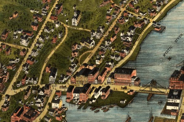
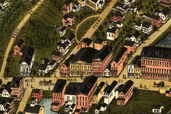
Below you will find an example of the enlargement ability of the maps contained on this CD. You will see how you can view a small snapshot of the image all the way up to an incredible level of detail at the highest resolutions. The below set of images comes from Mystic CT and gives an excellent example of the level of detail in these maps at various levels of "magnification".
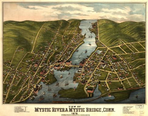
(Smallest size of this image)
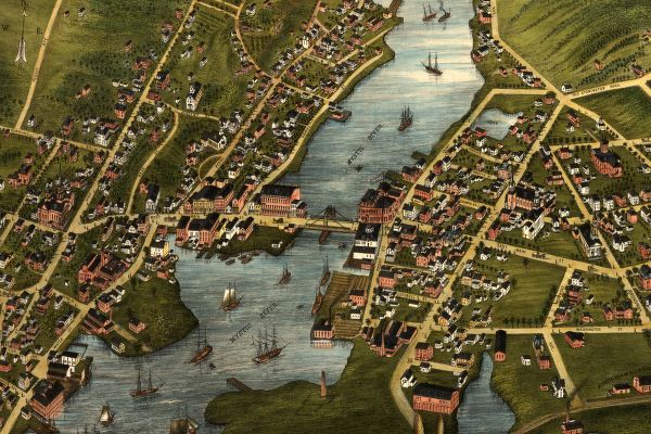
(Small portion enlarged 2 times)
(Small portion enlarged 3 times)
(Small portion enlarged 4 times)
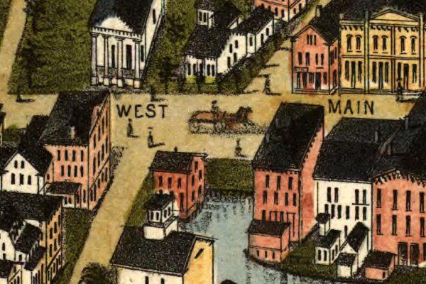
(Small portion enlarged 5 times - this enlargement represents the full
original size of the map when printed at full scale.)
As you can see from the above images, each map offers hours of exploration and excitement as you explore the cities as they were 100 or more years ago.
These maps may be viewed on your computer or printed out. The software will allow you to size the maps to any level of detail you wish and either print out the entire map or just a portion of it. (Even full scale maps can be printed with a large enough printer - like the ones used in your neighborhood poster and print shops.)
To use this software, you must install the free Map Viewing software which is included on the CD. This is a 30 second process and will allow you to view and manipulate/print all the maps in this CD collection in full detail. There are versions for Windows platforms and full installation instructions are included on the CD.