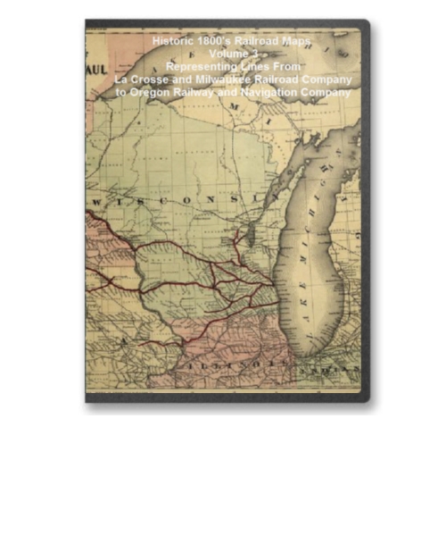
Historic 1800's Railroad Maps Volume 3 Representing Lines From La Crosse and Milwaukee Railroad Company to Oregon Railway and Navigation Company
The Railroad maps represent an important historical record, illustrating the growth of travel and settlement as well as the development of industry and agriculture in the United States. They depict the development of cartographic style and technique, highlighting the achievement of early railroaders. Included in the collection are progress report surveys for individual lines, official government surveys, promotional maps, maps showing land grants and rights-of-way, and route guides published by commercial firms.
Below is a small sampling of the maps on this CD. And below the maps is a table with a description of the entirety of the maps offered on this CD. Each map is stored in MrSID format.
This format allows you to see the entire map on your computer screen or drill down to see the smallest details. The original maps are often quite large, as much as 36" long or larger and quite detailed. With the MrSID software, you can manipulate the map to print the entire map in great detail or zoom into a portion of the map in full detail for viewing or printing. You could even bring the images to a local print shop to have the maps reprinted in their full size. (MrSID software is included on the CD.)
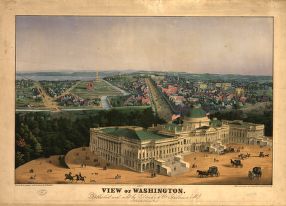
To give you a sample of the detail you can expect in these maps, here is an example based on a panoramic map of Washington, DC.
 |
 |
 |
 |
|
|
This CD Contains 81 Railroad Maps from Railroad Lines Danville and La Crosse and Milwaukee Railroad Company to Oregon Railway and Navigation Company. Here is a list of all the Railroad Lines represented.
|
|
Each map contains a wealth of interesting details to explore over and over again. This is a must have collection for any 19th century American railroad buff. With this CD, you will be able to trace the old railroads that made this country great in the 19th century and learn many interesting facts about the various railroad lines both from the provided descriptions and the detailed annotations found on many of the maps.
To use this software, you must install the free ExpressView MrSid software which is included on the CD. This is a 30 second process and will allow you to view and manipulate/print all the maps in this CD collection in full detail. There is a version for Windows platforms and full installation instructions are included on the CD.
 Michigan Southern Railroad. Skeleton map, showing the position and connections of the Michigan Southern Rail Road (from Toledo to Chicago) with the several great rail road routes to the Atlantic seaboard and New York City via the south shore of Lake Erie. Outline map of the northeastern United States showing railroads in operation, under construction, and under proposal. Chartered in 1846 and consolidated April 1855 with the Northern Indiana Railroad under the name Michigan Southern and Northern Indiana Railroad. Jervis, John B. (John Bloomfield), 1795-1885. CREATED/PUBLISHED N[ew] Y[ork], 1850. Scale ca. 1:3,000,000.
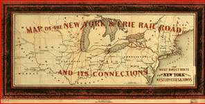 New York and Erie Railroad Company. Map of New York & Erie Rail Road and its connections; the most direct route from New York to all western cities and towns. Outline map of the northeastern and north-central United States with the railroad network overprinted in red. A red border is printed around the map simulating a wooden frame. Colton, J. H. (Joseph Hutchins), 1800-1893. CREATED/PUBLISHED N[ew] Y[ork] J.H. Colton & Co., 1855. Scale ca. 1:3,250,000.
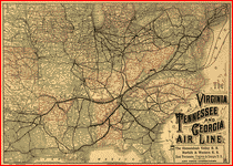 Norfolk and Western Railroad Company. The Virginia, Tennessee, and Georgia Air Line; the Shenandoah Valley R.R.; Norfolk & Western R.R.; East Tennessee, Virginia, & Georgia R.R. (its leased lines,) and their connections. Map of the eastern United States showing relief by hachures, drainage, cities and towns, and the railroad network emphasizing the main lines. Rand McNally and Company. CREATED/PUBLISHED Chicago, 1882.
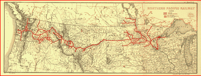 Northern Pacific Railroad Company. Northern Pacific Railway 1900. Map of northern United States from the Great Lakes to the Pacific Ocean showing reliief by hachures, drainage, cities and towns, forest and timber, Indian and military reservations. L.L. Poates Engr'g Co. CREATED/PUBLISHED New York, 1900.