This
CD contains 56 rare historic maps and descriptive pages representing
fascinating details about South Carolina and its vicinity
during the Civil War in MrSid format.
This
format allows you to see the entire map on your computer screen
or drill down to see the smallest details. The original maps
are often quite large, as much as 36" long or larger
and quite detailed. With the MrSID software, you can manipulate
the map to print the entire map in great detail or zoom into
a portion of the map in full detail for viewing or printing.
You could even bring the images to a local print shop to have
the maps reprinted in their full size. (MrSID software is
included on the CD.)
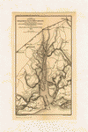
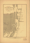
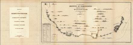
To
give you a sample of the detail you can expect in these maps,
here is an example based on a panoramic map of Washington,
DC.
The
table below shows the description and a small image of each
map on this fascinating civil war history CD.
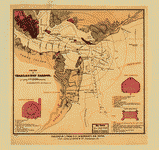
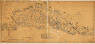
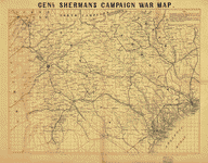 Genl.
Sherman's campaign war map. Bufford, John Henry, 1810-1870.
CREATED/PUBLISHED Boston, [1864] NOTES Scale ca. 1:670,000.
"The horizontal and upright lines [of the map grid] represent
five miles square. By referring [sic] to the number on
the left and to the letter on the base, any point may
be found to show the locality of the Union armies." Genl.
Sherman's campaign war map. Bufford, John Henry, 1810-1870.
CREATED/PUBLISHED Boston, [1864] NOTES Scale ca. 1:670,000.
"The horizontal and upright lines [of the map grid] represent
five miles square. By referring [sic] to the number on
the left and to the letter on the base, any point may
be found to show the locality of the Union armies." |
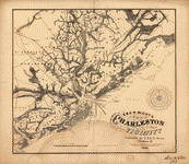
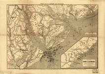
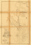
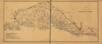
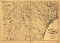 Southern
Georgia and part of South Carolina / U.S. Coast Survey,
A.D. Bache, supdt. ; drawn by A. Lindenkohl ; Chas. G.
Krebs, lith. United States Coast Survey. CREATED/PUBLISHED
[Washington, D.C.] : The Survey, 1865. NOTES Relief shown
by hachures. Includes list of authorities. Southern
Georgia and part of South Carolina / U.S. Coast Survey,
A.D. Bache, supdt. ; drawn by A. Lindenkohl ; Chas. G.
Krebs, lith. United States Coast Survey. CREATED/PUBLISHED
[Washington, D.C.] : The Survey, 1865. NOTES Relief shown
by hachures. Includes list of authorities. |
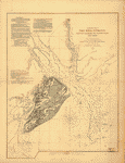
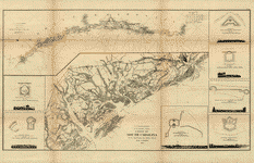
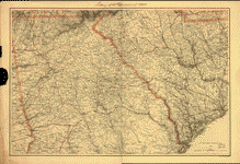 Northern
Georgia and western and central South Carolina] Drawn
by A. Lindenkohl. H. Lindenkohl & Chas. G. Krebs, lith.
Lindenkohl, A. CREATED/PUBLISHED [S.l.], U.S. Coast Survey,
A. D. Bache, Supdt., 1865 NOTES Scale 1:633,600. General
map, without title, extending from Charleston west to
the western boundary of Georgia. State names, boundaries,
and railroads are overprinted in red. Northern
Georgia and western and central South Carolina] Drawn
by A. Lindenkohl. H. Lindenkohl & Chas. G. Krebs, lith.
Lindenkohl, A. CREATED/PUBLISHED [S.l.], U.S. Coast Survey,
A. D. Bache, Supdt., 1865 NOTES Scale 1:633,600. General
map, without title, extending from Charleston west to
the western boundary of Georgia. State names, boundaries,
and railroads are overprinted in red. |
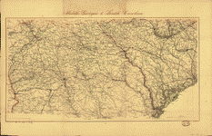 Middle
Georgia & South Carolina / U.S. Coast Survey, A. D. Bache,
supt. ; drawn by A. Lindenkohl ; Chas. G. Krebs, lith.
United States Coast Survey. CREATED/PUBLISHED [Washington]
: The Survey, [1865?] NOTES Scale ca. 1:633,600; 1 in.
= 10 miles. Relief shown by hachures. Middle
Georgia & South Carolina / U.S. Coast Survey, A. D. Bache,
supt. ; drawn by A. Lindenkohl ; Chas. G. Krebs, lith.
United States Coast Survey. CREATED/PUBLISHED [Washington]
: The Survey, [1865?] NOTES Scale ca. 1:633,600; 1 in.
= 10 miles. Relief shown by hachures. |
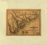
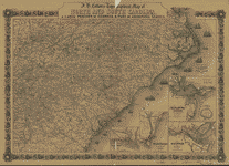 J.
H. Colton's topographical map of North and South Carolina.
A large portion of Georgia & part of adjoining states.
Entered according to Act of Congress in the year 1861
by J.H. Colton. Colton, J. H. (Joseph Hutchins), 1800-1893.
CREATED/PUBLISHED New York Printed by Lang & Laing 1861.
NOTES Scale ca. 1:1,550,000. Indicates forts, towns, roads,
railroads, county names and boundaries, geographic coordinates,
and rivers. Drawings of ships offshore denote naval blockade.
Insets: Beaufort and vicinity, N. Carolina. 8 x 9 cm.-Wilmington
and vicinity, N. Carolina. 13 x 9 cm.-Charleston Harbor
and its approaches, S. Carolina. 14 x 15 cm.-Plan of Ft.
Sumter. 4 x 4 cm.-Savannah and vicinity. 10 x 15 cm. J.
H. Colton's topographical map of North and South Carolina.
A large portion of Georgia & part of adjoining states.
Entered according to Act of Congress in the year 1861
by J.H. Colton. Colton, J. H. (Joseph Hutchins), 1800-1893.
CREATED/PUBLISHED New York Printed by Lang & Laing 1861.
NOTES Scale ca. 1:1,550,000. Indicates forts, towns, roads,
railroads, county names and boundaries, geographic coordinates,
and rivers. Drawings of ships offshore denote naval blockade.
Insets: Beaufort and vicinity, N. Carolina. 8 x 9 cm.-Wilmington
and vicinity, N. Carolina. 13 x 9 cm.-Charleston Harbor
and its approaches, S. Carolina. 14 x 15 cm.-Plan of Ft.
Sumter. 4 x 4 cm.-Savannah and vicinity. 10 x 15 cm. |
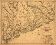
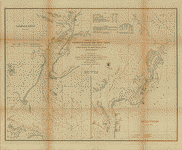
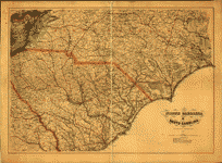 North
Carolina & South Carolina Drawn by A. Lindenkohl. Chas.
G. Krebs, lith. Lindenkohl, A. CREATED/PUBLISHED [S.l.],
U.S. Coast Survey, A. D. Bache, Supdt., 1865. NOTES Scale
1:633,600. General map. "Authorities" used in making the
map are listed below the title. State names, boundaries,
and railroads are overprinted in red. North
Carolina & South Carolina Drawn by A. Lindenkohl. Chas.
G. Krebs, lith. Lindenkohl, A. CREATED/PUBLISHED [S.l.],
U.S. Coast Survey, A. D. Bache, Supdt., 1865. NOTES Scale
1:633,600. General map. "Authorities" used in making the
map are listed below the title. State names, boundaries,
and railroads are overprinted in red. |
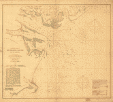
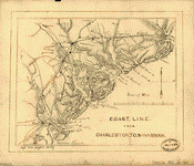 Coast
line from Charleston to Savannah. CREATED/PUBLISHED [1862?]
NOTES Scale ca. 1:430,000. Coast
line from Charleston to Savannah. CREATED/PUBLISHED [1862?]
NOTES Scale ca. 1:430,000. |
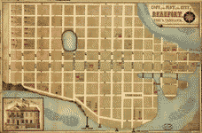 Copy
of the plot of the city of Beaufort, South Carolina /
drawn by B. Schelten, expressily [sic] for Dr. Clymer,
surg. U.S. Schelten, B. CREATED/PUBLISHED [186-] NOTES
Scale not given. Relief shown by hachures. Includes index
of military hospitals and col. ill. of "Chief Office." Copy
of the plot of the city of Beaufort, South Carolina /
drawn by B. Schelten, expressily [sic] for Dr. Clymer,
surg. U.S. Schelten, B. CREATED/PUBLISHED [186-] NOTES
Scale not given. Relief shown by hachures. Includes index
of military hospitals and col. ill. of "Chief Office."
|
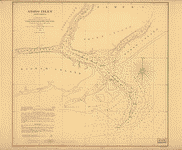
 Broad
River and its tributaries, S.C. From a reconnaissance
made, under direction of Rear Admiral J. A. Dahlgren,
Commd'g S.A.B. Squadron, by R. Platt, Act. Master, U.S.N.
und [sic] E. Willenbucher, U.S.C.S. 1864. Drawn by Eugene
Willenbucher. Bowen & Co., lith., Philada. Willenburger,
Eugene. CREATED/PUBLISHED [Washington, Government Printing
Office, 1865] NOTES Scale ca. 1:230,000. Broad
River and its tributaries, S.C. From a reconnaissance
made, under direction of Rear Admiral J. A. Dahlgren,
Commd'g S.A.B. Squadron, by R. Platt, Act. Master, U.S.N.
und [sic] E. Willenbucher, U.S.C.S. 1864. Drawn by Eugene
Willenbucher. Bowen & Co., lith., Philada. Willenburger,
Eugene. CREATED/PUBLISHED [Washington, Government Printing
Office, 1865] NOTES Scale ca. 1:230,000. |
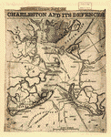
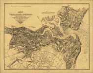
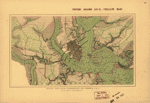 Map
of Charleston Harbor showing defenses. 186-] Section from
Atlas accompanying war records U.S.A. by courtesy of Julius
Bien & Co. Peter Adams Company. CREATED/PUBLISHED [S.l.,
18--?] NOTES Scale not given. Map
of Charleston Harbor showing defenses. 186-] Section from
Atlas accompanying war records U.S.A. by courtesy of Julius
Bien & Co. Peter Adams Company. CREATED/PUBLISHED [S.l.,
18--?] NOTES Scale not given. |
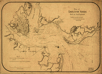
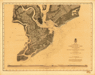
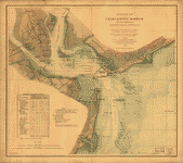
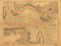 Map
of Charleston Harbor, S.C. Bowen & Co. CREATED/PUBLISHED
Philada., Bowen & Co's lith., [18--?] NOTES Scale ca.
1:15,800. Red curves are marked 6, 12, 18, and 24 feet
to show depths at mean low water. The area always covered
with water is blue, the surface between high and low water
marks is indicated by wavy lines and colored with bistre.
Shows drainage, vegetation, cultivated areas, roads, and
houses. The forts are circumscribed by 9-inch circles,
which show the range of their guns, with the exception
of Fort Sumter, where the range is different and is indicated
by three radii. Map
of Charleston Harbor, S.C. Bowen & Co. CREATED/PUBLISHED
Philada., Bowen & Co's lith., [18--?] NOTES Scale ca.
1:15,800. Red curves are marked 6, 12, 18, and 24 feet
to show depths at mean low water. The area always covered
with water is blue, the surface between high and low water
marks is indicated by wavy lines and colored with bistre.
Shows drainage, vegetation, cultivated areas, roads, and
houses. The forts are circumscribed by 9-inch circles,
which show the range of their guns, with the exception
of Fort Sumter, where the range is different and is indicated
by three radii. |
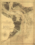
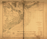 Preliminary
chart of Charleston Harbor and its approaches. United
States Coast Survey. CREATED/PUBLISHED [S.l.], Published
in 1858. Additions in 1862. NOTES Inscribed in ink: Transferred
from Office of Chf. Engr., Defenses of Washington, to
Engr. Dept., Jany. 1866. DLC Shows fortifications, towns,
soundings, roads and streets, vegetation, and drainage.
Includes "view of main ship channel" and "view off north
channel." Preliminary
chart of Charleston Harbor and its approaches. United
States Coast Survey. CREATED/PUBLISHED [S.l.], Published
in 1858. Additions in 1862. NOTES Inscribed in ink: Transferred
from Office of Chf. Engr., Defenses of Washington, to
Engr. Dept., Jany. 1866. DLC Shows fortifications, towns,
soundings, roads and streets, vegetation, and drainage.
Includes "view of main ship channel" and "view off north
channel." |
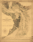
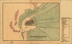
 Sketch
of Charleston Harbor By W. A. Williams, Civil Engineer.
Williams, W. A. CREATED/PUBLISHED Boston, L. Prang & Co.,
[186-?] NOTES Scale ca. 1:70,000. Shows fortifications,
street pattern of Charleston, vegetation, and a few soundings.
Insets: Castle Pinckney. 7 x 5 cm-Fort Sumpter [sic].
7 x 6 cm-Fort Moultrie. 5 x 6 cm. Sketch
of Charleston Harbor By W. A. Williams, Civil Engineer.
Williams, W. A. CREATED/PUBLISHED Boston, L. Prang & Co.,
[186-?] NOTES Scale ca. 1:70,000. Shows fortifications,
street pattern of Charleston, vegetation, and a few soundings.
Insets: Castle Pinckney. 7 x 5 cm-Fort Sumpter [sic].
7 x 6 cm-Fort Moultrie. 5 x 6 cm. |
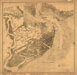
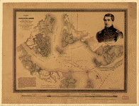 Part
of Charleston Harbor, embracing forts Moultrie, Sumter,
Johnson, and Castle Pinckney, also Sullivan, James & Morris
islands; and showing the position of the Star of the West,
when fired into from Morris Island. Perry, George T. CREATED/PUBLISHED
Philadela., Lith. P.S. Duval & Son, c1861. NOTES Scale
ca. 1:31,000. Shows the channel, drainage, vegetation,
roads, plan of the city, and forts. A portrait of Major
Anderson, commander of Fort Sumter, is in the upper right
corner. Below the neat line is a view of the harbor and
city from Fort Johnson to Mt. Pleasant. Part
of Charleston Harbor, embracing forts Moultrie, Sumter,
Johnson, and Castle Pinckney, also Sullivan, James & Morris
islands; and showing the position of the Star of the West,
when fired into from Morris Island. Perry, George T. CREATED/PUBLISHED
Philadela., Lith. P.S. Duval & Son, c1861. NOTES Scale
ca. 1:31,000. Shows the channel, drainage, vegetation,
roads, plan of the city, and forts. A portrait of Major
Anderson, commander of Fort Sumter, is in the upper right
corner. Below the neat line is a view of the harbor and
city from Fort Johnson to Mt. Pleasant. |
 Plan
of Charleston Harbor, and its fortifications compiled
by Elliot & Ames from government surveys. Elliot & Ames.
CREATED/PUBLISHED Boston, C. D. Andrews' lith., 1861.
NOTES Scale 1:31,680. Shows channel, low water mark and
soundings, drainage, roads, railroads, some dwellings,
a plan of the city, and forts. Plan
of Charleston Harbor, and its fortifications compiled
by Elliot & Ames from government surveys. Elliot & Ames.
CREATED/PUBLISHED Boston, C. D. Andrews' lith., 1861.
NOTES Scale 1:31,680. Shows channel, low water mark and
soundings, drainage, roads, railroads, some dwellings,
a plan of the city, and forts. |
 Charleston
Harbor and its approaches showing the positions of the
Rebel batteries. United States Coast Survey. CREATED/PUBLISHED
N.Y., Lith. of J. Bien, [1863] NOTES Scale 1:30,000. Another
issue. Shows roads, railroads, houses, vegetation, a street
plan of Charleston, drainage, soundings, and shoals. Overprinted
to show 1/4-mile concentric circles centered on St. Michaels,
Charleston; positions occupied by the Union Army and Navy;
"Rebel batteries in possession of National forces [and]
batteries still held by the Rebels [on] Sept. 7th 1863."
Union positions are based "on the authority of Maj. T.
B. Brooks . . ." Charleston
Harbor and its approaches showing the positions of the
Rebel batteries. United States Coast Survey. CREATED/PUBLISHED
N.Y., Lith. of J. Bien, [1863] NOTES Scale 1:30,000. Another
issue. Shows roads, railroads, houses, vegetation, a street
plan of Charleston, drainage, soundings, and shoals. Overprinted
to show 1/4-mile concentric circles centered on St. Michaels,
Charleston; positions occupied by the Union Army and Navy;
"Rebel batteries in possession of National forces [and]
batteries still held by the Rebels [on] Sept. 7th 1863."
Union positions are based "on the authority of Maj. T.
B. Brooks . . ." |
 Charleston
Harbor and its approaches showing the positions of the
Rebel batteries. United States Coast Survey. CREATED/PUBLISHED
[S.l, 1863] NOTES [Scale 1:30,000]. Another issue. Shows
roads, railroads, houses, vegetation, a street plan of
Charleston, drainage, soundings, and shoals. Overprinted
to show positions occupied by the Union Army and Navy,
and "Rebel batteries in possession [of] National forces
[and] batteries still held by the Rebels [on] Sept. 7,
1863." Charleston
Harbor and its approaches showing the positions of the
Rebel batteries. United States Coast Survey. CREATED/PUBLISHED
[S.l, 1863] NOTES [Scale 1:30,000]. Another issue. Shows
roads, railroads, houses, vegetation, a street plan of
Charleston, drainage, soundings, and shoals. Overprinted
to show positions occupied by the Union Army and Navy,
and "Rebel batteries in possession [of] National forces
[and] batteries still held by the Rebels [on] Sept. 7,
1863." |
 Charleston
Harbor and its approaches showing the positions of the
Rebel batteries. United States Coast Survey. CREATED/PUBLISHED
N.Y., J. Bien, lith., [1863] NOTES Scale ca. 1:30,000.
Another issue. Shows roads, railroads, houses, vegetation,
a street plan of Charleston, drainage, soundings, and
shoals. Enlarged issue covering all of James Island and
indicating 1/2-mile concentric circles centered on St.
Michaels, Charleston, "first [and] second line[s] of Rebel
defences," positions occupied by the Union Army and Navy,
and "Rebel batteries in possession [of] National forces
[and] batteries still held by the Rebels [on] Sept. 7th
1863." Charleston
Harbor and its approaches showing the positions of the
Rebel batteries. United States Coast Survey. CREATED/PUBLISHED
N.Y., J. Bien, lith., [1863] NOTES Scale ca. 1:30,000.
Another issue. Shows roads, railroads, houses, vegetation,
a street plan of Charleston, drainage, soundings, and
shoals. Enlarged issue covering all of James Island and
indicating 1/2-mile concentric circles centered on St.
Michaels, Charleston, "first [and] second line[s] of Rebel
defences," positions occupied by the Union Army and Navy,
and "Rebel batteries in possession [of] National forces
[and] batteries still held by the Rebels [on] Sept. 7th
1863." |
 New
map of Charleston Harbor, showing the scene of the great
naval contest between the iron clad monitors and the Rebel
batteries, also the lines of fire, forts, obstructions,
inlets, princl. plantations, & e.t.c. Tomlinson, G. W.
(George W.) CREATED/PUBLISHED Boston, Lith. by J. Mayer
& Co., c1863. NOTES Scale not given. Shows the coast from
Long Island to the North Edisto River. Indicates drainage,
roads, railroads, and dwellings with names of inhabitants.
Channels, water depths, forts and batteries, with lines
of fire, are given. The following title appears in the
lower right corner: Tomlinson's map of Charleston Harbor,
S.C., and vicinity, showing the fortifications and batteries,
together with a full description of the harbor, forts,
obstructions, bombardment & et.c. Drawings of the Ericsson
"Devil" and the iron clad "Keokuk," and plans of Fort
Sumter, Fort Moultrie, and Castle Pinckney are in the
lower right corner. A column of text entitled "Description
of the harbor, forts, &c." is in the right margin. New
map of Charleston Harbor, showing the scene of the great
naval contest between the iron clad monitors and the Rebel
batteries, also the lines of fire, forts, obstructions,
inlets, princl. plantations, & e.t.c. Tomlinson, G. W.
(George W.) CREATED/PUBLISHED Boston, Lith. by J. Mayer
& Co., c1863. NOTES Scale not given. Shows the coast from
Long Island to the North Edisto River. Indicates drainage,
roads, railroads, and dwellings with names of inhabitants.
Channels, water depths, forts and batteries, with lines
of fire, are given. The following title appears in the
lower right corner: Tomlinson's map of Charleston Harbor,
S.C., and vicinity, showing the fortifications and batteries,
together with a full description of the harbor, forts,
obstructions, bombardment & et.c. Drawings of the Ericsson
"Devil" and the iron clad "Keokuk," and plans of Fort
Sumter, Fort Moultrie, and Castle Pinckney are in the
lower right corner. A column of text entitled "Description
of the harbor, forts, &c." is in the right margin. |
 Charleston
Harbor and its approaches showing the positions of the
Rebel batteries. United States Coast Survey. CREATED/PUBLISHED
[S.l.], 1863. NOTES Scale 1:30,000. Shows roads, railroads,
houses, vegetation, a street plan of Charleston, drainage,
soundings, and shoals. Charleston
Harbor and its approaches showing the positions of the
Rebel batteries. United States Coast Survey. CREATED/PUBLISHED
[S.l.], 1863. NOTES Scale 1:30,000. Shows roads, railroads,
houses, vegetation, a street plan of Charleston, drainage,
soundings, and shoals. |
 Resurvey
of Charleston Bar by W. S. Edwards, Asst. and F. P. Webber,
Sub-Asst., under the direction of C. O. Boutelle, Assistant,
1864. Redd. Drng. by J. J. Ricketts & A. Boschke. Engd.
by F. Dankworth, J. Knight, E. Yeager & G. McCoy. United
States Coast Survey. CREATED/PUBLISHED [S.l., 1864] NOTES
Scale 1:30,000. "No. 15" is in the upper left corner. Resurvey
of Charleston Bar by W. S. Edwards, Asst. and F. P. Webber,
Sub-Asst., under the direction of C. O. Boutelle, Assistant,
1864. Redd. Drng. by J. J. Ricketts & A. Boschke. Engd.
by F. Dankworth, J. Knight, E. Yeager & G. McCoy. United
States Coast Survey. CREATED/PUBLISHED [S.l., 1864] NOTES
Scale 1:30,000. "No. 15" is in the upper left corner.
|
 Charleston
Harbor and city defences Entered according to Act of Congress
in the year 1864 by D. N. Dobelmann & G. Huck. Dobelmann,
D. N. CREATED/PUBLISHED [S.l.], T. B. Usser, 1864. NOTES
Scale ca. 1:170,000. "Key to the map of Charleston Harbor
and defences" is pasted to the right of the map. "Green
represents the Confederates" land [and] pink the Federal
possessions" Indicates "torpedoes in the channels," obstructions,
bridges, roads and streets, railroads, and rivers. Letters
A to K represent fortifications, headquarters, depots,
and "place where Clarck of Brooklin was executed." Forts
and batteries are numbered 1 to 40. The number of guns
and mortars for each is shown opposite the name given
in the "Key" Charleston
Harbor and city defences Entered according to Act of Congress
in the year 1864 by D. N. Dobelmann & G. Huck. Dobelmann,
D. N. CREATED/PUBLISHED [S.l.], T. B. Usser, 1864. NOTES
Scale ca. 1:170,000. "Key to the map of Charleston Harbor
and defences" is pasted to the right of the map. "Green
represents the Confederates" land [and] pink the Federal
possessions" Indicates "torpedoes in the channels," obstructions,
bridges, roads and streets, railroads, and rivers. Letters
A to K represent fortifications, headquarters, depots,
and "place where Clarck of Brooklin was executed." Forts
and batteries are numbered 1 to 40. The number of guns
and mortars for each is shown opposite the name given
in the "Key" |
 Sketch
showing position of besieging batteries. [Fort Sumter]
April 12-13, 1861 Bowen & Co., lith., Phila. Foster, John
G. (John Gray), 1823-1874. CREATED/PUBLISHED [Washington,
Government Printing Office, 1866] NOTES Scale ca. 1:30,800. Sketch
showing position of besieging batteries. [Fort Sumter]
April 12-13, 1861 Bowen & Co., lith., Phila. Foster, John
G. (John Gray), 1823-1874. CREATED/PUBLISHED [Washington,
Government Printing Office, 1866] NOTES Scale ca. 1:30,800.
|
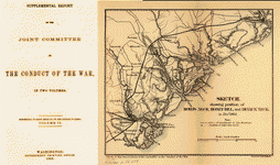
 Map
of the defences of Charleston city and harbor, showing
also the works erected by the U.S. forces in 1863 and
1864 To accompany the report of Major Genl. Q. A. Gillmore,
U.S. Vols. United States. Army. Corps of Engineers. CREATED/PUBLISHED
[S.l., 186-] NOTES Scale 1:60,000. At bottom of map: View
off North Channel, For Sumter 3 1/2 miles distant, bearing
W. 3/4 N., Febry. 18th 1865. This map without the Corps
of Engineers' insignia appears as Plate II of the Supplementary
Report published with Q. A. Gillmore's Engineer and Artillery
Operations Against the Defenses of Charleston Harbor in
1863; with a Supplement. (New York, D. Van Nostrand, 1868).
314, 172 p. (U.S. Army. Corps of Engineers. Professional
papers, no. 16) Shows drainage, vegetation, roads, railroads,
soundings, shoals, channels, forts, batteries, picket
line of the U.S. forces, plan of the city with the "effective,
annoying [and] extreme range" of guns from Cumming's Point. Map
of the defences of Charleston city and harbor, showing
also the works erected by the U.S. forces in 1863 and
1864 To accompany the report of Major Genl. Q. A. Gillmore,
U.S. Vols. United States. Army. Corps of Engineers. CREATED/PUBLISHED
[S.l., 186-] NOTES Scale 1:60,000. At bottom of map: View
off North Channel, For Sumter 3 1/2 miles distant, bearing
W. 3/4 N., Febry. 18th 1865. This map without the Corps
of Engineers' insignia appears as Plate II of the Supplementary
Report published with Q. A. Gillmore's Engineer and Artillery
Operations Against the Defenses of Charleston Harbor in
1863; with a Supplement. (New York, D. Van Nostrand, 1868).
314, 172 p. (U.S. Army. Corps of Engineers. Professional
papers, no. 16) Shows drainage, vegetation, roads, railroads,
soundings, shoals, channels, forts, batteries, picket
line of the U.S. forces, plan of the city with the "effective,
annoying [and] extreme range" of guns from Cumming's Point.
|
 E.
& G. W. Blunt's map of Charleston and vicinity. E. & G.W.
Blunt (Firm). CREATED/PUBLISHED [New York], 1862. NOTES
Scale ca. 1:151,000. Indicates fortifications, roads,
railroads, towns, street pattern of Charleston, drainage,
vegetation, and ship channels. E.
& G. W. Blunt's map of Charleston and vicinity. E. & G.W.
Blunt (Firm). CREATED/PUBLISHED [New York], 1862. NOTES
Scale ca. 1:151,000. Indicates fortifications, roads,
railroads, towns, street pattern of Charleston, drainage,
vegetation, and ship channels. |
 Charleston
and its defences. Philadelphia Inquirer (Firm) CREATED/PUBLISHED
Philadelphia, 1863. NOTES Scale ca. 1:52,000. From The
Philadelphia Inquirer, Saturday, April 11, 1863, p. 1.
Map indicates forts, batteries, obstructions, and torpedoes
(i.e., mines) Charleston
and its defences. Philadelphia Inquirer (Firm) CREATED/PUBLISHED
Philadelphia, 1863. NOTES Scale ca. 1:52,000. From The
Philadelphia Inquirer, Saturday, April 11, 1863, p. 1.
Map indicates forts, batteries, obstructions, and torpedoes
(i.e., mines) |
 Defences
of Charleston, South Carolina From a reconnaissance made
by direction of C. O. Boutelle, Asst. U.S.C.S., by E.
Willenbucher. 1865. Bowen & Co., lith., Philada. Willenbucher,
Eugene. CREATED/PUBLISHED [Washington, Government Printing
Office, 1865] NOTES Scales 1:2000 and 1:4000. Defences
of Charleston, South Carolina From a reconnaissance made
by direction of C. O. Boutelle, Asst. U.S.C.S., by E.
Willenbucher. 1865. Bowen & Co., lith., Philada. Willenbucher,
Eugene. CREATED/PUBLISHED [Washington, Government Printing
Office, 1865] NOTES Scales 1:2000 and 1:4000. |
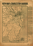
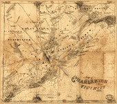 Map
of Charleston and vicinity. CREATED/PUBLISHED 1862. NOTES
Scale ca. 1:170,000. Map
of Charleston and vicinity. CREATED/PUBLISHED 1862. NOTES
Scale ca. 1:170,000. |
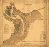
 General
map of Charleston Harbor, South Carolina, showing rebel
defences and obstructions. Drawn by E. Willenbücher, Chas.
G. Krebs, Lith. Willenbucher, Eugene. CREATED/PUBLISHED
[Washington] 1865. NOTES Scale 1:30,000. Depths shown
by gradient tints. Shows location of sunken ships. Includes
table of rebel forts. General
map of Charleston Harbor, South Carolina, showing rebel
defences and obstructions. Drawn by E. Willenbücher, Chas.
G. Krebs, Lith. Willenbucher, Eugene. CREATED/PUBLISHED
[Washington] 1865. NOTES Scale 1:30,000. Depths shown
by gradient tints. Shows location of sunken ships. Includes
table of rebel forts. |
 Map
of Charleston and its defences Compiled from surveys of
portions of St. Andrews and Christ Ch. parishes by Lieut.
John Johnson, C.S. Engrs., the harbor, James Id., Folly
Id., Morris Id., Sullivans Id., & Long Id., from U.S.
Coast Survey, Johns Id., from Mills Atlas. Under the direction
of Maj; Wm. H. Echols, C.S. Engr. Corps, by Wm. A. Walker,
Draughtsman, C.S. Engr. Corps. Drawn by John R. Key, 2nd.
Lieut., C.S. Engr. Charleston, S.C., Nov: 28th, 1863.
Walker, William A. CREATED/PUBLISHED [S.l., 1885] NOTES
Scale 1:63,360 (not "2 inches to 1 mile"). In upper left
corner: Copied for his excellency M. L. Bonham Governor
of the State of South Carolina. In lower margin: Reproduced
for Mayor Courtenay's city year book, from the original
map in the possession of the Chamber of Commerce, Charleston,
S.C. Detailed map showing forts and batteries, roads,
railroads, towns, houses and names of residents, vegetation,
drainage, and soundings in Charleston Harbor and offshore. Map
of Charleston and its defences Compiled from surveys of
portions of St. Andrews and Christ Ch. parishes by Lieut.
John Johnson, C.S. Engrs., the harbor, James Id., Folly
Id., Morris Id., Sullivans Id., & Long Id., from U.S.
Coast Survey, Johns Id., from Mills Atlas. Under the direction
of Maj; Wm. H. Echols, C.S. Engr. Corps, by Wm. A. Walker,
Draughtsman, C.S. Engr. Corps. Drawn by John R. Key, 2nd.
Lieut., C.S. Engr. Charleston, S.C., Nov: 28th, 1863.
Walker, William A. CREATED/PUBLISHED [S.l., 1885] NOTES
Scale 1:63,360 (not "2 inches to 1 mile"). In upper left
corner: Copied for his excellency M. L. Bonham Governor
of the State of South Carolina. In lower margin: Reproduced
for Mayor Courtenay's city year book, from the original
map in the possession of the Chamber of Commerce, Charleston,
S.C. Detailed map showing forts and batteries, roads,
railroads, towns, houses and names of residents, vegetation,
drainage, and soundings in Charleston Harbor and offshore.
|
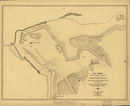 Fort
Johnson, section of map of the defences of Charleston
Harbor, South Carolina surveyed between March 7th & May
20th, 1865, under the direction of Brevet Major General
R. Delafield, Chief Engineer, U.S. Army. Surveyed April
20th, 1865, by J. E. Weyss, Maj., U.S.V.; assisted by
Mr. F. Theilkuhl & E. Schumann. United States. Army. Corps
of Engineers. CREATED/PUBLISHED N.Y., Am Photo. Litho.
Co., [1865] NOTES Scale 1:1200. Below neat line of map:
Furnished by the War Department to the City Council of
Charleston, S.C. Shows topography by hachures, drainage,
vegetation, batteries, and a detailed plan of the fortifications. Fort
Johnson, section of map of the defences of Charleston
Harbor, South Carolina surveyed between March 7th & May
20th, 1865, under the direction of Brevet Major General
R. Delafield, Chief Engineer, U.S. Army. Surveyed April
20th, 1865, by J. E. Weyss, Maj., U.S.V.; assisted by
Mr. F. Theilkuhl & E. Schumann. United States. Army. Corps
of Engineers. CREATED/PUBLISHED N.Y., Am Photo. Litho.
Co., [1865] NOTES Scale 1:1200. Below neat line of map:
Furnished by the War Department to the City Council of
Charleston, S.C. Shows topography by hachures, drainage,
vegetation, batteries, and a detailed plan of the fortifications.
|
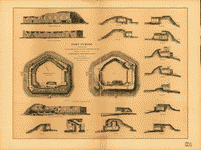 Fort
Sumter, South Carolina at the time of its capture February
18th, 1865. Showing the effects of the bombardment from
Morris Island To accompany the report of Maj. Genl. Q.
A. Gillmore, U.S. Vols., comdg. Dept. of the South. United
States. Army. Corps of Engineers. CREATED/PUBLISHED N.Y.,
Julius Bien & Co., photo-lith., [186-] NOTES Scale 1:240
and 1:600. Sheet contains a plan of the fort, a horizontal
section, 3 elevations, and 13 sections. Fort
Sumter, South Carolina at the time of its capture February
18th, 1865. Showing the effects of the bombardment from
Morris Island To accompany the report of Maj. Genl. Q.
A. Gillmore, U.S. Vols., comdg. Dept. of the South. United
States. Army. Corps of Engineers. CREATED/PUBLISHED N.Y.,
Julius Bien & Co., photo-lith., [186-] NOTES Scale 1:240
and 1:600. Sheet contains a plan of the fort, a horizontal
section, 3 elevations, and 13 sections. |
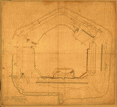 Plan
of Fort Sumter, South Carolina] : surveyed, March 20th,
22, 27, 1865. CREATED/PUBLISHED 1865. NOTES Pen-and-ink
and watercolor. "Red lines [denote] remainder of walls
of old Ft. Sumter; Red dotted [lines indicate] souterains
of walls of old Ft. Sumter; blue dotted [lines signify]
souterains built out of the rubbish; [and] black [lines
indicate] interior and exterior limits of Sumter at date." Plan
of Fort Sumter, South Carolina] : surveyed, March 20th,
22, 27, 1865. CREATED/PUBLISHED 1865. NOTES Pen-and-ink
and watercolor. "Red lines [denote] remainder of walls
of old Ft. Sumter; Red dotted [lines indicate] souterains
of walls of old Ft. Sumter; blue dotted [lines signify]
souterains built out of the rubbish; [and] black [lines
indicate] interior and exterior limits of Sumter at date."
|
 Map
showing siege operations against forts Sumter and Wagner,
between July 13th & Sept. 7th, 1863, Maj. T. B. Brooks,
A.D.C. & Assist. Engrs. Published by permission of Genl.
Gillmore at the U.S. Coast Survey Office. Brooks, T. B.
(Thomas Benton), 1836-1900. CREATED/PUBLISHED [S.l., 1863]
NOTES Scale ca. 1:6,750. Shows drainage, roads, high and
low water line, 6-ft. and 12-ft. depth curve, batteries,
trenches, stockades, and a plan of Fort Wagner. Fort Sumter
does not appear on this map, only the line of fire to
the fort from the breaching batteries south of Fort Wagner. Map
showing siege operations against forts Sumter and Wagner,
between July 13th & Sept. 7th, 1863, Maj. T. B. Brooks,
A.D.C. & Assist. Engrs. Published by permission of Genl.
Gillmore at the U.S. Coast Survey Office. Brooks, T. B.
(Thomas Benton), 1836-1900. CREATED/PUBLISHED [S.l., 1863]
NOTES Scale ca. 1:6,750. Shows drainage, roads, high and
low water line, 6-ft. and 12-ft. depth curve, batteries,
trenches, stockades, and a plan of Fort Wagner. Fort Sumter
does not appear on this map, only the line of fire to
the fort from the breaching batteries south of Fort Wagner.
|
 Defences
of Charleston Harbor. Fortifications on James Island From
a reconaissance made under direction of C. O. Boutelle,
Assistant U.S.C.S., by Eugene Willenbucher. 1865. Lith.
Bowen & Co., Philada. Willenbucher, Eugene. CREATED/PUBLISHED
[Washington, Government Printing Office, 1865] NOTES Scales
1:2000 and 1:4000. cludes plans of batteries Glover, Haskall
and Wampler, and Fort Johnson. Also included are 18 profiles
of the defensive works. Defences
of Charleston Harbor. Fortifications on James Island From
a reconaissance made under direction of C. O. Boutelle,
Assistant U.S.C.S., by Eugene Willenbucher. 1865. Lith.
Bowen & Co., Philada. Willenbucher, Eugene. CREATED/PUBLISHED
[Washington, Government Printing Office, 1865] NOTES Scales
1:2000 and 1:4000. cludes plans of batteries Glover, Haskall
and Wampler, and Fort Johnson. Also included are 18 profiles
of the defensive works. |
 Carte
de Port Royal et des environs : avec un plan de la côte
du sud, depuis Bull's Bay (Caroline du Sud), jusqu'ŕ Brunswick
(Géorgie), indiquant les moyens de communication entre
Beaufort, Savanah [sic] Ft. Charleston / drawn by G. Woolworth
Colton, N.Y. Colton, G. Woolworth (George Woolworth),
1827-1901. CREATED/PUBLISHED [New York] : Courrier des
États-Unis, [186-?] NOTES Scale ca. 1:160,000. Depths
shown by contours. Ships shown pictorially. Inset: Part
of the coast of S. Carolina showing the relative positions
of Charleston, Beaufort & Savannah. Carte
de Port Royal et des environs : avec un plan de la côte
du sud, depuis Bull's Bay (Caroline du Sud), jusqu'ŕ Brunswick
(Géorgie), indiquant les moyens de communication entre
Beaufort, Savanah [sic] Ft. Charleston / drawn by G. Woolworth
Colton, N.Y. Colton, G. Woolworth (George Woolworth),
1827-1901. CREATED/PUBLISHED [New York] : Courrier des
États-Unis, [186-?] NOTES Scale ca. 1:160,000. Depths
shown by contours. Ships shown pictorially. Inset: Part
of the coast of S. Carolina showing the relative positions
of Charleston, Beaufort & Savannah. |
 Preliminary
chart of Port Royal entrance. Beaufort, Chechessee, and
Colleton Rivers, South Carolina From a trigonometrical
survey under the direction of A. D. Bache, Superindent
of the survey of the coast of the United States. Triangulation
by C. O. Boutelle, Assist. Hydrography by the parties
under the command of Lieuts. Commdg. J. N. Maffit and
C. M. Fauntleroy, U.S.N, Assists. United States Coast
Survey. CREATED/PUBLISHED [Washington, U.S. Coast Survey],
1862. NOTES Scale 1:60,000. "No. 18" is in the upper left
corner. Detailed nautical chart showing Hilton Head Island
and vicinity. Indicated are soundings, bottom contours,
and vegetation. Includes sailing directions. Preliminary
chart of Port Royal entrance. Beaufort, Chechessee, and
Colleton Rivers, South Carolina From a trigonometrical
survey under the direction of A. D. Bache, Superindent
of the survey of the coast of the United States. Triangulation
by C. O. Boutelle, Assist. Hydrography by the parties
under the command of Lieuts. Commdg. J. N. Maffit and
C. M. Fauntleroy, U.S.N, Assists. United States Coast
Survey. CREATED/PUBLISHED [Washington, U.S. Coast Survey],
1862. NOTES Scale 1:60,000. "No. 18" is in the upper left
corner. Detailed nautical chart showing Hilton Head Island
and vicinity. Indicated are soundings, bottom contours,
and vegetation. Includes sailing directions. |
 Preliminary
chart of Port Royal entrance, Beaufort, Broad and Chechessee
Rivers, South Carolina From a trigonometrical survey under
the direction of A. D. Bache,Superintendent of the survey
of the coast of the United States. Triangulation by C.
O. Boutelle, Asst. Hydrography by the parties under the
command of Lieuts. Comdg. J. N. Maffitt, C. M. Fauntleroy,
and J. P. Bankhead, U.S.N., Assists. and of C. O. Boutelle,
Asst. and W. S. Edwards, Sub-Asst. United States Coast
Survey. CREATED/PUBLISHED [Washington, U.S. Coast Survey],
1862. NOTES Scale 1:60,000. Preliminary
chart of Port Royal entrance, Beaufort, Broad and Chechessee
Rivers, South Carolina From a trigonometrical survey under
the direction of A. D. Bache,Superintendent of the survey
of the coast of the United States. Triangulation by C.
O. Boutelle, Asst. Hydrography by the parties under the
command of Lieuts. Comdg. J. N. Maffitt, C. M. Fauntleroy,
and J. P. Bankhead, U.S.N., Assists. and of C. O. Boutelle,
Asst. and W. S. Edwards, Sub-Asst. United States Coast
Survey. CREATED/PUBLISHED [Washington, U.S. Coast Survey],
1862. NOTES Scale 1:60,000. |
 Map
of St. Helena Sound, and the coast between Charleston
and Savannah Compiled from the U.S. Coast Survey. Lith
by C. D. Andrews & Co., Boston. A. Williams & Co. CREATED/PUBLISHED
Boston, A. Williams & Co., 1861. NOTES Scale ca. 1:385,000.
Shows forts, towns, roads, railroads, rivers, and islands.
Insets: Fort Walker. 4 x 3 cm.-Fort Beauregard. 4 x 3
cm. Map
of St. Helena Sound, and the coast between Charleston
and Savannah Compiled from the U.S. Coast Survey. Lith
by C. D. Andrews & Co., Boston. A. Williams & Co. CREATED/PUBLISHED
Boston, A. Williams & Co., 1861. NOTES Scale ca. 1:385,000.
Shows forts, towns, roads, railroads, rivers, and islands.
Insets: Fort Walker. 4 x 3 cm.-Fort Beauregard. 4 x 3
cm. |
 Preliminary
chart of St. Helena Sound, South Carolina From a trigonometrical
survey under the direction of A. D. Bache, Superintendent
of the survey of the coast of the United States. Triangulation
by C. O. Boutelle and C. P. Bolles, Assistants. Topography
by John Seib, Assistant. Hydrography by the parties under
the command of Lieut. Comdg. J. N. Maffitt, U.S.N. and
C. O. Boutelle, Assists. United States Coast Survey. CREATED/PUBLISHED
[Washington, U.S. Coast Survey], 1864. NOTES Scale 1:40,000. Preliminary
chart of St. Helena Sound, South Carolina From a trigonometrical
survey under the direction of A. D. Bache, Superintendent
of the survey of the coast of the United States. Triangulation
by C. O. Boutelle and C. P. Bolles, Assistants. Topography
by John Seib, Assistant. Hydrography by the parties under
the command of Lieut. Comdg. J. N. Maffitt, U.S.N. and
C. O. Boutelle, Assists. United States Coast Survey. CREATED/PUBLISHED
[Washington, U.S. Coast Survey], 1864. NOTES Scale 1:40,000.
|
 Stono
Inlet, South Carolina From a trigonometrical survey under
the direction of A. D. Bache, Superintendent of the survey
of the coast of the United States. Triangulation, topography
and hydrography by the parties under the direction of
C. O. Boutelle, Assist., Coast Survey. Drawn by E. Willenbucher.
Chas. G. Krebs, lith. Willenbucher, Eugene. CREATED/PUBLISHED
[Washington, U.S. Coast Survey], 1862. NOTES Scale 1:20,000.
Preliminary edition. "The triangulation was executed in
1852; the topography and hydrography were executed in
1862." General chart showing soundings and bottom contours.
Includes sailing directions. Stono
Inlet, South Carolina From a trigonometrical survey under
the direction of A. D. Bache, Superintendent of the survey
of the coast of the United States. Triangulation, topography
and hydrography by the parties under the direction of
C. O. Boutelle, Assist., Coast Survey. Drawn by E. Willenbucher.
Chas. G. Krebs, lith. Willenbucher, Eugene. CREATED/PUBLISHED
[Washington, U.S. Coast Survey], 1862. NOTES Scale 1:20,000.
Preliminary edition. "The triangulation was executed in
1852; the topography and hydrography were executed in
1862." General chart showing soundings and bottom contours.
Includes sailing directions. |
 Defences
of Charleston S.C. Fortifications on Sullivan's Island
From a reconaissance made under direction of C. O. Boutelle,
Assistant U.S.C.S., by Eugene Willenbucher. 1865. Bowen
& Co., lith., Philada. CREATED/PUBLISHED [Washington,
Government Printing Office, 1865] NOTES Scale ca. 1:4000.
Map shows Battery Bee and forts Moultrie, Beauregard,
and Marshall. Included are 21 profiles of the defensive
works. A "List of guns" appears in the lower left corner. Defences
of Charleston S.C. Fortifications on Sullivan's Island
From a reconaissance made under direction of C. O. Boutelle,
Assistant U.S.C.S., by Eugene Willenbucher. 1865. Bowen
& Co., lith., Philada. CREATED/PUBLISHED [Washington,
Government Printing Office, 1865] NOTES Scale ca. 1:4000.
Map shows Battery Bee and forts Moultrie, Beauregard,
and Marshall. Included are 21 profiles of the defensive
works. A "List of guns" appears in the lower left corner.
|
 Map
of the environs of Savannah, Georgia. 186-] Drawn by A.
Lindenkoh. Chas. G. Krebs, lith. Lindenkohl, A. CREATED/PUBLISHED
[S.l., 186-] NOTES Scale not given. Printed map without
title. Indicates fortifications, roads, railroads, drainage,
vegetation, towns, and some houses and names of residents
in outlying areas. Map
of the environs of Savannah, Georgia. 186-] Drawn by A.
Lindenkoh. Chas. G. Krebs, lith. Lindenkohl, A. CREATED/PUBLISHED
[S.l., 186-] NOTES Scale not given. Printed map without
title. Indicates fortifications, roads, railroads, drainage,
vegetation, towns, and some houses and names of residents
in outlying areas. |
 Map
of the seat of war, in South Carolina, and Georgia. Evans
& Cogswell. CREATED/PUBLISHED Charleston, S.C., Evans
& Cogswell, [1861] NOTES Scale ca. 1:450,000. Inset: Portion
of Georgia [around Savannah]. Uncolored. Scale not given.
11 x 17 cm. Confederate imprint. Shows coastal area from
Georgetown, South Carolina, to Savannah, Georgia, and
territory inland as far north as Kingstree, South Carolina,
to Orangeburgh, South Carolina. Gives the location of
forts and shows coastal shoals, drainage, roads, railroads,
ferries, bridges, dwellings with names of inhabitants,
churches, and post offices. Map
of the seat of war, in South Carolina, and Georgia. Evans
& Cogswell. CREATED/PUBLISHED Charleston, S.C., Evans
& Cogswell, [1861] NOTES Scale ca. 1:450,000. Inset: Portion
of Georgia [around Savannah]. Uncolored. Scale not given.
11 x 17 cm. Confederate imprint. Shows coastal area from
Georgetown, South Carolina, to Savannah, Georgia, and
territory inland as far north as Kingstree, South Carolina,
to Orangeburgh, South Carolina. Gives the location of
forts and shows coastal shoals, drainage, roads, railroads,
ferries, bridges, dwellings with names of inhabitants,
churches, and post offices. |
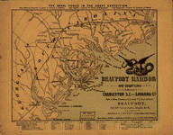 Beaufort
Harbor and coast line between Charleston, S.C. and Savanna
[sic] Ga., with 5 mile distance lines in circles round
Beaufort, and R.R. connections, roads, &c, &c. L. Prang
& Co. CREATED/PUBLISHED Boston, [1861?] NOTES Scale not
given. Indicates ships in Beaufort Harbor and a few of
the line coastal forts. "The naval force in the great
expedition" appears above the map, followed by the names
of commanding officers. Below the neat line at the bottom
of the map appear the names of the ships, the captains,
and the number of guns aboard each ship. Beaufort
Harbor and coast line between Charleston, S.C. and Savanna
[sic] Ga., with 5 mile distance lines in circles round
Beaufort, and R.R. connections, roads, &c, &c. L. Prang
& Co. CREATED/PUBLISHED Boston, [1861?] NOTES Scale not
given. Indicates ships in Beaufort Harbor and a few of
the line coastal forts. "The naval force in the great
expedition" appears above the map, followed by the names
of commanding officers. Below the neat line at the bottom
of the map appear the names of the ships, the captains,
and the number of guns aboard each ship. |
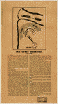 Sea
coast defences. Manigault, Gabriel E. (Gabriel Edward),
1833-1899. CREATED/PUBLISHED [S.l., 1861?] NOTES Scale
not given. Confederate imprint. Suggested "system of defence
for smaller ports and inlets" in South Carolina, signed
"G.M." and illustrated by a plan of a fort. Gabriel Manigault
(1809-1888) was the author of a "Letter Addressed to Governor
M. L. Bonham, of South Carolina, on the Defences of Charleston"
(1863) Sea
coast defences. Manigault, Gabriel E. (Gabriel Edward),
1833-1899. CREATED/PUBLISHED [S.l., 1861?] NOTES Scale
not given. Confederate imprint. Suggested "system of defence
for smaller ports and inlets" in South Carolina, signed
"G.M." and illustrated by a plan of a fort. Gabriel Manigault
(1809-1888) was the author of a "Letter Addressed to Governor
M. L. Bonham, of South Carolina, on the Defences of Charleston"
(1863) |
 Sketch
of portions of seacoast of South Carolina & Georgia Drawn
by A. Lindenkohl. Autogr. copy by H. Lindenkohl. Lindenkohl,
A. CREATED/PUBLISHED [S.l.], 1862. NOTES Scale 1:200,000.
Autographed in ink: Gen. M. C. Meigs USA. Map of the coast
from Bull's Bay, South Carolina, to Ossabaw Sound, Georgia,
showing forts, drainage, roads, railroads, and towns.
"References" at the bottom center of the map give dates
on which forts were captured by the Federal forces. Sketch
of portions of seacoast of South Carolina & Georgia Drawn
by A. Lindenkohl. Autogr. copy by H. Lindenkohl. Lindenkohl,
A. CREATED/PUBLISHED [S.l.], 1862. NOTES Scale 1:200,000.
Autographed in ink: Gen. M. C. Meigs USA. Map of the coast
from Bull's Bay, South Carolina, to Ossabaw Sound, Georgia,
showing forts, drainage, roads, railroads, and towns.
"References" at the bottom center of the map give dates
on which forts were captured by the Federal forces. |
 Coast
of South Carolina from Charleston to Hilton Head. United
States Coast Survey. CREATED/PUBLISHED [Washington, U.S.
Coast Survey], 1862. NOTES Scale 1:200,000. Insets: Plan
and view of Fort "Beauregard"-Bay Point, S.C. Scale 1:2000.
16 x 17 cm.-Fort on Fenwick's Island, S.C. Scale 1:1000.
13 x 15 cm.-Ground plan and view of fort on Bay Point-South
Edisto R., S.C. Scale 1:1000. 14 x 15 cm.-Plan and view
of fort on Otter Isld. Point-St. Helena Sound, S.C. Scale
1:1000. 12 x 15 cm.-Fort on Sam's Point, Coosaw River,
S.C. Scale 1:1000. 13 x 15 cm.-Ground plan and view of
fort on Botany-Bay Isld., North Edisto R. Scale 1:2000.
12 x 15 cm.-Fort "Walker"-Hilton Head Isld., S.C. Scale
1:2000. 13 x 15 cm.-Sketch E showing the progress of the
survey in section no. V from 1847 to 1862. [Triangulation
network from Winyah Bay, South Carolina, to Amelia Island,
Florida] Scale 1:600,000. 24 x 74 cm. Coast
of South Carolina from Charleston to Hilton Head. United
States Coast Survey. CREATED/PUBLISHED [Washington, U.S.
Coast Survey], 1862. NOTES Scale 1:200,000. Insets: Plan
and view of Fort "Beauregard"-Bay Point, S.C. Scale 1:2000.
16 x 17 cm.-Fort on Fenwick's Island, S.C. Scale 1:1000.
13 x 15 cm.-Ground plan and view of fort on Bay Point-South
Edisto R., S.C. Scale 1:1000. 14 x 15 cm.-Plan and view
of fort on Otter Isld. Point-St. Helena Sound, S.C. Scale
1:1000. 12 x 15 cm.-Fort on Sam's Point, Coosaw River,
S.C. Scale 1:1000. 13 x 15 cm.-Ground plan and view of
fort on Botany-Bay Isld., North Edisto R. Scale 1:2000.
12 x 15 cm.-Fort "Walker"-Hilton Head Isld., S.C. Scale
1:2000. 13 x 15 cm.-Sketch E showing the progress of the
survey in section no. V from 1847 to 1862. [Triangulation
network from Winyah Bay, South Carolina, to Amelia Island,
Florida] Scale 1:600,000. 24 x 74 cm. |
 Preliminary
chart of Calibogue Sound and Skull Creek forming inside
passage from Tybee Roads to Port Royal Sound, South Carolina
From a trigonometrical survey under the direction of A.
D. Bache, Superintendent of the survey of the coast of
the United States. Triangulation by C. O. Boutelle, C.
P. Bolles, Capt. E.O.C. Ord, and Lieut. D. T. Van Buren,
U.S.A. Assts. Typography by C. Rockwell, Sub Asst. Hydrography
by the parties under the command of Lieut. Comdg. J. N.
Maffitt, U.S.N. Asst. and W. S. Edwards, Sub-Asst. United
States Coast Survey. CREATED/PUBLISHED [Washington U.S.
Coast Survey] 1862. NOTES Scale 1:40,000. Preliminary
chart of Calibogue Sound and Skull Creek forming inside
passage from Tybee Roads to Port Royal Sound, South Carolina
From a trigonometrical survey under the direction of A.
D. Bache, Superintendent of the survey of the coast of
the United States. Triangulation by C. O. Boutelle, C.
P. Bolles, Capt. E.O.C. Ord, and Lieut. D. T. Van Buren,
U.S.A. Assts. Typography by C. Rockwell, Sub Asst. Hydrography
by the parties under the command of Lieut. Comdg. J. N.
Maffitt, U.S.N. Asst. and W. S. Edwards, Sub-Asst. United
States Coast Survey. CREATED/PUBLISHED [Washington U.S.
Coast Survey] 1862. NOTES Scale 1:40,000. |
 Plans
& views of Rebel defences, coast of South Carolina Drawn
by E. Willenbucher, under the direction of C. O. Boutelle,
Assist., U.S. Coast Survey. Willenbucher, Eugene. CREATED/PUBLISHED
Philada., Bowen & Co., lith., 1862 NOTES Scale not given.
Contents: Fort "Walker," Hilton Head Isld., S.C. Scale
1:2000. 17 x 15 cm.-Ground plan and view of fort on Botany-Bay
Isld. North Edisto R. Scale 1:2000. 12 x 15 cm.-Fort on
Sam's Point, Coosaw River, S.C. Scale 1:1000. 13 x 15
cm.-Ground plan and view of fort on Bay Point South Edisto
R., S.C. Scale 1:1000. 14 x 15 cm.-Plan and view of Fort
"Beauregard," Bay Point, S.C. Scale 1:2000. 17 x 17 cm.-Plan
and view of fort on Otter Isld. Point, St. Helena Sound,
S.C. Scale 1:1600. 12 x 17 cm.-Fort on Fenwick's Island,
S.C. Scale 1:1000. 13 x 17 cm. At the bottom of each map
is a view of the fort. Plans
& views of Rebel defences, coast of South Carolina Drawn
by E. Willenbucher, under the direction of C. O. Boutelle,
Assist., U.S. Coast Survey. Willenbucher, Eugene. CREATED/PUBLISHED
Philada., Bowen & Co., lith., 1862 NOTES Scale not given.
Contents: Fort "Walker," Hilton Head Isld., S.C. Scale
1:2000. 17 x 15 cm.-Ground plan and view of fort on Botany-Bay
Isld. North Edisto R. Scale 1:2000. 12 x 15 cm.-Fort on
Sam's Point, Coosaw River, S.C. Scale 1:1000. 13 x 15
cm.-Ground plan and view of fort on Bay Point South Edisto
R., S.C. Scale 1:1000. 14 x 15 cm.-Plan and view of Fort
"Beauregard," Bay Point, S.C. Scale 1:2000. 17 x 17 cm.-Plan
and view of fort on Otter Isld. Point, St. Helena Sound,
S.C. Scale 1:1600. 12 x 17 cm.-Fort on Fenwick's Island,
S.C. Scale 1:1000. 13 x 17 cm. At the bottom of each map
is a view of the fort. |
 Sketch
of portions of seacoast of South Carolina & Georgia Drawn
by A. Lindenkohl.]. Lindenkohl, A. CREATED/PUBLISHED [S.l.],
1863. NOTES [Scale 1:200,000]. Map of the coast from Bull's
Bay, South Carolina, to Ossabaw Sound, Georgia, showing
forts, drainage, roads, railroads, and towns. "References"
is printed in the lower left corner. Sketch
of portions of seacoast of South Carolina & Georgia Drawn
by A. Lindenkohl.]. Lindenkohl, A. CREATED/PUBLISHED [S.l.],
1863. NOTES [Scale 1:200,000]. Map of the coast from Bull's
Bay, South Carolina, to Ossabaw Sound, Georgia, showing
forts, drainage, roads, railroads, and towns. "References"
is printed in the lower left corner. |
 Sketch
of sea coast of South Carolina and Georgia from Bull's
Bay to Ossabaw Sound / drawn by A. Lindenkohl ; E. Molitor,
lith. Lindenkohl, A. CREATED/PUBLISHED [Washington] :
U.S. Coast Survey, 1863. NOTES Scale 1:200,000. Sketch
of sea coast of South Carolina and Georgia from Bull's
Bay to Ossabaw Sound / drawn by A. Lindenkohl ; E. Molitor,
lith. Lindenkohl, A. CREATED/PUBLISHED [Washington] :
U.S. Coast Survey, 1863. NOTES Scale 1:200,000. |
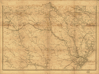 Part
of South Carolina and Georgia] Engineer Bureau, Dec. 24th
1864. United States. Army. Corps of Engineers. CREATED/PUBLISHED
[S.l., 1864] NOTES Scale 1:350,000. Southern half of an
unidentified printed map. Sheet extends from Augusta south
to Jacksonville, Georgia, and Beaufort, South Carolina,
west to Eatonton, Georgia. Indicated are roads and railroads,
cities and towns, houses and names of residents, rivers,
and forts. Part
of South Carolina and Georgia] Engineer Bureau, Dec. 24th
1864. United States. Army. Corps of Engineers. CREATED/PUBLISHED
[S.l., 1864] NOTES Scale 1:350,000. Southern half of an
unidentified printed map. Sheet extends from Augusta south
to Jacksonville, Georgia, and Beaufort, South Carolina,
west to Eatonton, Georgia. Indicated are roads and railroads,
cities and towns, houses and names of residents, rivers,
and forts. |
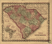 Colton's
South Carolina. Colton, J. H. (Joseph Hutchins), 1800-1893.
CREATED/PUBLISHED New York, J. H. Colton 1865. NOTES Scale
ca. 1:1,3000,000. General map showing county and state
boundaries, cities and towns, roads and railroads, rivers,
and forts. Insets: Colton's plan of Charleston, vicinity
& harbor. 12 x 10 cm.-Fort Sumter. 3 x 3 cm. Colton's
South Carolina. Colton, J. H. (Joseph Hutchins), 1800-1893.
CREATED/PUBLISHED New York, J. H. Colton 1865. NOTES Scale
ca. 1:1,3000,000. General map showing county and state
boundaries, cities and towns, roads and railroads, rivers,
and forts. Insets: Colton's plan of Charleston, vicinity
& harbor. 12 x 10 cm.-Fort Sumter. 3 x 3 cm. |
 Sketch
showing position of Boyd's Neck, Honey Hill, and Devaux'
Neck, in Decr. 1864 Bowen & Co., lith., Philada. Foster,
John G. (John Gray), 1823-1874. CREATED/PUBLISHED [Washington,
Government Printing Office, 1866] NOTES Scale ca. 1:670,00
(not "1 inch=10 miles"). Map indicates "lines of investment
of Gen. Sherman" at Savannah, Georgia, Boyd's Neck, Honey
Hill and Devaux' Neck, South Carolina, and "position of
rebel ironclads" on the Savannah River. Sketch
showing position of Boyd's Neck, Honey Hill, and Devaux'
Neck, in Decr. 1864 Bowen & Co., lith., Philada. Foster,
John G. (John Gray), 1823-1874. CREATED/PUBLISHED [Washington,
Government Printing Office, 1866] NOTES Scale ca. 1:670,00
(not "1 inch=10 miles"). Map indicates "lines of investment
of Gen. Sherman" at Savannah, Georgia, Boyd's Neck, Honey
Hill and Devaux' Neck, South Carolina, and "position of
rebel ironclads" on the Savannah River. |
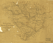 Railroad
map of South Carolina by Jed. Hotchkiss, T.E., Stanton,
Va., 1880. Hotchkiss, Jedediah, 1828-1899. NOTES Scale
ca. 1:1,250,000. Pen-and-ink sketch showing drainage,
counties, cities and towns, and the railroads with names
along the lines. Railroad
map of South Carolina by Jed. Hotchkiss, T.E., Stanton,
Va., 1880. Hotchkiss, Jedediah, 1828-1899. NOTES Scale
ca. 1:1,250,000. Pen-and-ink sketch showing drainage,
counties, cities and towns, and the railroads with names
along the lines. |
This is a must have collection for any civil war history
buff!
To use
this software, you must install the free ExpressView MrSid
software which is included on the CD. This is a 30 second
process and will allow you to view and manipulate/print all
the maps in this CD collection in full detail. There is a
version for both Windows platforms and Macintosh platforms
and full installation instructions are included on the CD. |


