Geographical Fun Atlas
 |
Geographical
Fun: Being Humourous Outlines of Various Countries was first
published in London by the firm of Hodder and Stoughton in 1869.
The atlas consists of twelve maps of European countries, each
with a unique national stereotype created by the author based
on the the outline and shape of the country. Each image is accompanied
by a short verse describing the authors creation.
In the
introduction to the atlas, the author, William Harvey, writing
under the pseudonym Aleph, described his intention in creating
the atlas: It is believed that illustrations of Geography
may be rendered educational, and prove of service to young
Scholars who commonly think Globes and Maps but wearisome
aids to knowledge. If these geographical puzzles excite the
mirth of children, the amusement of the moment may lead to
the profitable curiosity of youthful students and embue the
mind with a healthful taste for foreign lands.
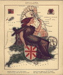
The resulting
fanciful caricatures include England in the form of 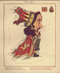 Queen Victoria; Scotland as a gallant Piper struggling
through the bogs; Wales in the form of Owen Glendowr; Ireland
as a Peasant, happy in her babys smile; France as an Empress
of cooks, fashions, and the dance; Spain and Portugal joined
in lasting amity; Italy as a revolutionary figure complete
with liberty cap; Prussia in the personages of Friedrich Wilhelm
and Prime Minister Bismarck; Holland and Belgium as female
figures who represent a land . . . and perfect art made grand;
Denmark as a female figure with ice skates; and Russia as
the classic bear.
Queen Victoria; Scotland as a gallant Piper struggling
through the bogs; Wales in the form of Owen Glendowr; Ireland
as a Peasant, happy in her babys smile; France as an Empress
of cooks, fashions, and the dance; Spain and Portugal joined
in lasting amity; Italy as a revolutionary figure complete
with liberty cap; Prussia in the personages of Friedrich Wilhelm
and Prime Minister Bismarck; Holland and Belgium as female
figures who represent a land . . . and perfect art made grand;
Denmark as a female figure with ice skates; and Russia as
the classic bear.


