The panoramic
map was a popular cartographic form used to depict U.S. and Canadian
cities and towns during the late nineteenth and early twentieth
centuries (1847 to 1929.) Known also as bird's-eye views, perspective
maps, and aero views, panoramic maps are nonphotographic representations
of cities portrayed as if viewed from above at an oblique angle.
Although not generally drawn to scale, they show street patterns,
individual buildings, and major landscape features in perspective.
Panoramic
maps graphically depict the vibrant life of a city. Harbors are
shown choked with ships, often to the extent of constituting hazards
to navigation. Trains speed along railroad tracks, at times on
the same roadbed with locomotives and cars headed in the opposite
direction. People and horsedrawn carriages fill the streets, and
smoke belches from the stacks of industrial plants. Urban and
industrial development in post-Civil War America is vividly portrayed
in the maps.
Victorian
America's panoramic maps are quite remarkable in the perspective
of the cities they capture. Most panoramic maps were published
independently, not as plates in an atlas or in a descriptive geographical
book. Preparation and sale of nineteenth-century panoramas were
motivated by civic pride and the desire of the city fathers to
encourage commercial growth. Many views were prepared for and
endorsed by chambers of commerce and other civic organizations
and were used as advertisements of a city's commercial and residential
potential. These maps reveal much about the great contrasts and
contradictions of the industrial age and the progressive era.
Preparation
of panoramic maps involved a vast amount of painstakingly detailed
labor. For each project a frame or projection was developed, showing
in perspective the pattern of streets. The artist then walked
in the street, sketching buildings, trees, and other features
to present a complete and accurate landscape as though seen from
an elevation of 2,000 to 3,000 feet.
Panoramic
maps graphically depict the vibrant life of a city. Harbors are
shown choked with ships, often to the extent of constituting hazards
to navigation. Trains speed along railroad tracks, at times on
the same roadbed with locomotives and cars headed in the opposite
direction. People and horsedrawn carriages fill the streets, and
smoke belches from the stacks of industrial plants. Urban and
industrial development in post-Civil War America is vividly portrayed
in the maps.
Here
is a complete list of the city maps included in this collection.
Where you see a city listed several times, there are several different
maps - either maps created in different years and/or by different
map making companies.
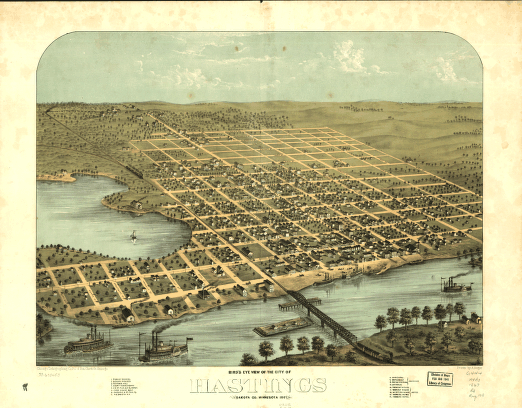
1. Anoka 1869
2. Appleton / Granite Falls / Montevideo / Preston 1874
3. Austin 1870
4. Brainerd 1914
5. Duluth 1883
6. Duluth 1887
7. Faribault 1869
8. Hastings 1867
9. Lake City 1867
10. Luverne 1883
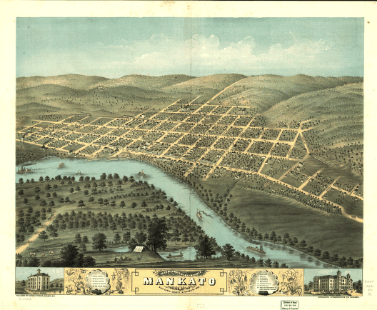
11. Mankato 1870
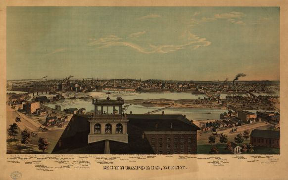
12. Minneapolis / Saint Anthony (Hennepin County) 1867
13. Minneapolis 1873
14. Minneapolis 1874
15. Minneapolis 1879
16. Minneapolis 1885
17. Minneapolis 1891
18. Minneapolis 1891
19. New Ulm 1870 |
20. Northfield 1869
21. Owatonna 1870
22. Red Wing 1868
23. Red Wing 1880
24. Rochester 1869
25. Saint Cloud 1869
26. Saint Paul 1853
27. Saint Paul 1867
28. Saint Paul 1873
29. Saint Paul 1874
30. Saint Paul 1883
31. Saint Paul 1888, 1887
32. Saint Paul 1893
33. Saint Paul 1906
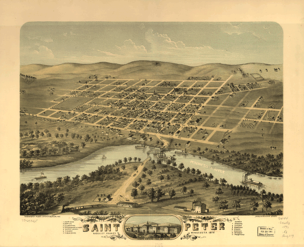
34. Saint Peter 1870
35. Shakopee 1869
36. Stillwater 1870
37. Winona County 1867
38. Winona 1867
39. Winona 1874
40. Winona 1889 |
Each map image
on this CD is a super high resolution scan of an original panoramic
map. Original maps were often as large as 36" x 36"
or even larger. To offer all these maps at 100% detail, they are
stored in either MRSid format or in JPEG 2000 format and require
special viewers to be able to view all the details in these superb
historical maps. Viewers and full viewing instructions for both
Windows and Macintosh computer platforms are included on this
CD.
Some Additional Map Samples
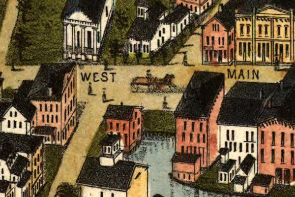
Below you
will find an example of the enlargement ability of the maps contained
on this CD. You will see how you can view a small snapshot of
the image all the way up to an incredible level of detail at the
highest resolutions. The below set of images comes from Mystic
CT and gives an excellent example of the level of detail in these
maps at various levels of "magnification".
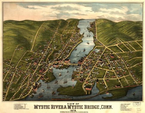
(Smallest size of this image)
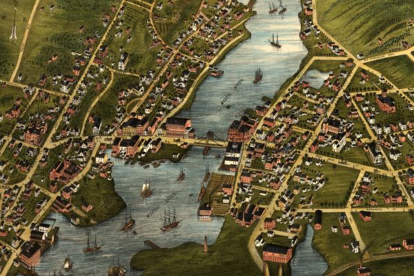
(Small portion enlarged 2 times)
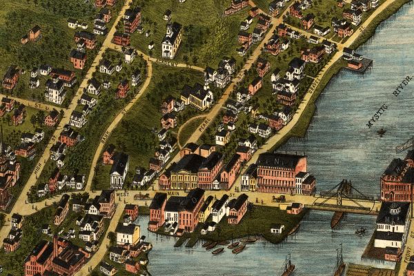
(Small portion enlarged 3 times)
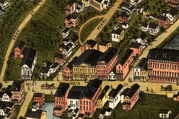
(Small portion enlarged 4 times)
(Small portion enlarged 5 times - this enlargement
represents the full
original size of the map when printed at full scale.)
As you can
see from the above images, each map offers hours of exploration
and excitement as you explore the cities as they were 100 or more
years ago.
These maps
may be viewed on your computer or printed out. The software will
allow you to size the maps to any level of detail you wish and
either print out the entire map or just a portion of it. (Even
full scale maps can be printed with a large enough printer - like
the ones used in your neighborhood poster and print shops.)
To use this
software, you must install the free Map Viewing software which
is included on the CD. This is a 30 second process and will allow
you to view and manipulate/print all the maps in this CD collection
in full detail. There are versions for both Windows platforms
and Macintosh platforms and full installation instructions are
included on the CD. |


