The Railroad
maps represent an important historical record, illustrating the
growth of travel and settlement as well as the development of
industry and agriculture in the United States. They depict the
development of cartographic style and technique, highlighting
the achievement of early railroaders. Included in the collection
are progress report surveys for individual lines, official government
surveys, promotional maps, maps showing land grants and rights-of-way,
and route guides published by commercial firms.
Below is a
small sampling of the maps on this CD. And below the maps is a
table with a description of the entirety of the maps offered on
this CD. Each map is stored in MrSID format.
This
format allows you to see the entire map on your computer screen
or drill down to see the smallest details. The original maps are
often quite large, as much as 36" long or larger and quite
detailed. With the MrSID software, you can manipulate the map
to print the entire map in great detail or zoom into a portion
of the map in full detail for viewing or printing. You could even
bring the images to a local print shop to have the maps reprinted
in their full size. (MrSID software is included on the CD.)
To
give you a sample of the detail you can expect in these maps,
here is an example based on a panoramic map of Washington, DC.
|
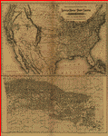 Pacific
Railroad. Map of South Pacific Rail Road Co. of Missouri.
Outline map of Arkansas and parts of Kansas, Oklahoma, and
Texas showing drainage, counties, cities and towns, finished
and projected railroads with names along the lines. Aug.
Gast & Co. CREATED/PUBLISHED [n.p.], 1870. Scale [ca. 1:2,500,000]. Pacific
Railroad. Map of South Pacific Rail Road Co. of Missouri.
Outline map of Arkansas and parts of Kansas, Oklahoma, and
Texas showing drainage, counties, cities and towns, finished
and projected railroads with names along the lines. Aug.
Gast & Co. CREATED/PUBLISHED [n.p.], 1870. Scale [ca. 1:2,500,000].
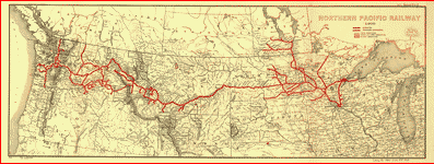
 Pacific
Railroad. Map of the country tributary to the Northern Pacific
Railroad, compiled from English, Canadian, and American
official sources and original surveys by Edward H. Knight,
Jan. 1st 1871. Map of northwest part of United States and
southwest part of Canada showing relief by hachures, drainage,
isotherms, the wheat region, cities and towns, forts, routes
and trails, the railroad network and the proposed Northern
Pacific Railroad. The line was constructed under an act
of Congress approved by Abraham Lincoln, July 2, 1864. It
was completed in 1883 and approximates the route of exploration
taken by Lewis and Clark in 1804-06. Knight, E. H. (Edward
H.) CREATED/PUBLISHED [n.p., 1871] Scale ca. 1:3,000,000. Pacific
Railroad. Map of the country tributary to the Northern Pacific
Railroad, compiled from English, Canadian, and American
official sources and original surveys by Edward H. Knight,
Jan. 1st 1871. Map of northwest part of United States and
southwest part of Canada showing relief by hachures, drainage,
isotherms, the wheat region, cities and towns, forts, routes
and trails, the railroad network and the proposed Northern
Pacific Railroad. The line was constructed under an act
of Congress approved by Abraham Lincoln, July 2, 1864. It
was completed in 1883 and approximates the route of exploration
taken by Lewis and Clark in 1804-06. Knight, E. H. (Edward
H.) CREATED/PUBLISHED [n.p., 1871] Scale ca. 1:3,000,000.
 Pennsylvania
Railroad. Map of the Pittsburg [sic], Fort Wayne & Chicago,
Cleveland and Pittsburg [sic], Grand Rapids and Indiana,
and Pennsylvania railroads. Map of the northeastern United
States showing relief by hachures, drainage, cities and
towns, and the railroad network with named lines. Emphasis
on the main lines. Rand McNally and Company. CREATED/PUBLISHED
Chicago, c1874. Scale ca. 1:4,500,000. Pennsylvania
Railroad. Map of the Pittsburg [sic], Fort Wayne & Chicago,
Cleveland and Pittsburg [sic], Grand Rapids and Indiana,
and Pennsylvania railroads. Map of the northeastern United
States showing relief by hachures, drainage, cities and
towns, and the railroad network with named lines. Emphasis
on the main lines. Rand McNally and Company. CREATED/PUBLISHED
Chicago, c1874. Scale ca. 1:4,500,000.
 Rockford,
Rock Island, and Saint Louis Railroad. Map showing the line
of the Rockford, Rock Island, & Saint Louis R.R. and its
connections. ws midwestern states with drainage, cities
and towns, township and county boundaries, and the railroad
network with emphasis on the main line. Consolidated October
8, 1868. G.W. & C.B. Colton & Co. CREATED/PUBLISHED New
York, 1868. Scale 1:1,267,200. Rockford,
Rock Island, and Saint Louis Railroad. Map showing the line
of the Rockford, Rock Island, & Saint Louis R.R. and its
connections. ws midwestern states with drainage, cities
and towns, township and county boundaries, and the railroad
network with emphasis on the main line. Consolidated October
8, 1868. G.W. & C.B. Colton & Co. CREATED/PUBLISHED New
York, 1868. Scale 1:1,267,200.
|
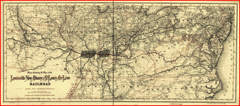
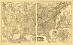
(The above are some of the maps on this CD)
And there are 67 more!
This
CD Contains 71 Railroad Maps from Pacific Railroad to Rutland
and Burlington Railroad. Here is a list of all the Railroad Lines
represented.
- Pacific Railroad.
- Pacific and Atlantic Railroad.
- Paterson Central Electric Railway.
- Paterson and Dover Railroad.
- Paterson and Ramapo Rail Road.
- Paterson, Passaic, and Rutherford Electric Railway.
- Pennsylvania Railroad
- Philadelphia & Reading Railroad Co.
- Philadelphia and Baltimore Railroad.
- Philadelphia and Erie Railroad.
- Philadelphia, Easton and Water Gap Railroad Company
- Philadelphia, Wilmington, and Baltimore Rail Road Company
- Phoenixville Cornwall Railroad.
- Pinegrove Lancaster Railroad.
- Pittsburgh, Bradford, and Buffalo Railway.
|
- Pittsburgh, Cincinnati and St. Louis Railway.
- Pittsburgh, Fort Wayne, and Chicago Railway Company
- Pittsburgh, Marion, and Chicago Railway.
- Plymouth, Kankakee, and Pacific Railroad.
- Port Royal Railroad.
- Portland and Ogdensburg Railroad.
- Portsmouth & Concord Railroad
- Potomac and Ohio Railway.
- Potomac, Fredericksburg, and Piedmont Railroad.
- Rabun Gap Railroad.
- Reading and Columbia Railroad.
- Richmond and Danville Railroad Company
- Richmond and Louisville Railroad.
- Rio Grande and Pecos Railway.
- Rockford, Rock Island, and Saint Louis Railroad.
- Royal Land Company.
- Rutland and Burlington Railroad
|
Each map contains
a wealth of interesting details to explore over and over again.
This is a must have collection for any 19th century American railroad
buff.
With this CD, you will be able to trace the old railroads that
made this country great in the 19th century and learn many interesting
facts about the various railroad lines both from the provided
descriptions and the detailed annotations found on many of the
maps.
To use this
software, you must install the free ExpressView MrSid software
which is included on the CD. This is a 30 second process and will
allow you to view and manipulate/print all the maps in this CD
collection in full detail. There is a version for both Windows
platforms and Macintosh platforms and full installation instructions
are included on the CD.
|


